
Explore October 2026 Amazonas wildfire data, PM2.5 measurements in Manaus and the environmental, occupational and public-health implications.
The emergency also arrives through the air
A wildfire does not need to reach a city street to disrupt everyday life. Smoke carries part of the problem beyond the flames, affects outdoor work and demands decisions about schools, transport and public services. In the Brazilian state of Amazonas, October 2026 brings these environmental and public-health challenges together.
Reuters reported on October 14, citing Censipam, that Amazonas registered 1,679 fire occurrences or detections during the first two weeks of October, 253% above the equivalent period in 2025. The report mentioned at least 36 municipalities under emergency declarations. This figure does not establish 1,679 independently confirmed, separate wildfire events.
Reporting cutoff: October 14, 2026, Brasília time (BRT). The figures below describe documented historical windows and do not update automatically. The principal geographical scope is Amazonas state. The wider Amazon region provides context for smoke transport and climate, but that context does not expand state-level statistics to the entire biome.
Before comparing numbers, ask what was counted
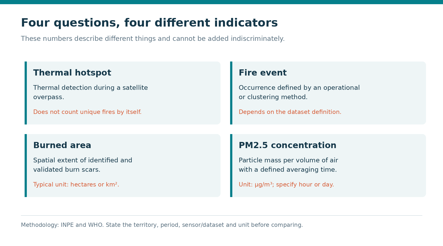
Fire detections, particle concentrations, burned area and response resources answer different questions. A two-week state total does not describe one person's respiratory exposure in Manaus, and an air-quality station does not count hectares affected by fire. Meaningful reporting preserves each indicator's geographical scope, period, units and measurement method alongside its numerical value.
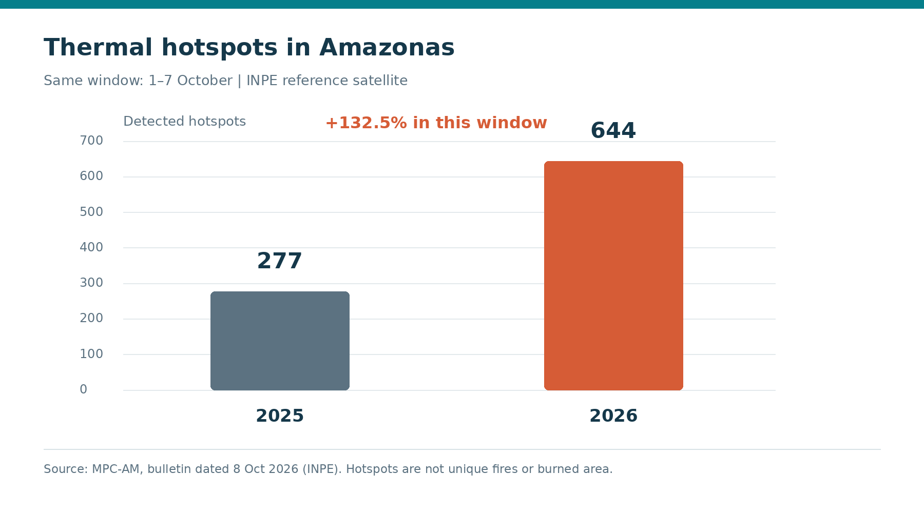
The MPC-AM bulletin dated October 8 reported 644 hotspots between October 1 and 7, 2026, against 277 on the same dates in 2025, using the INPE reference satellite AQUA_M-T. The calculation is (644 − 277) / 277 × 100 = 132.49%, rounded to a 132.5% increase for this particular series.
That increase does not compete with the 253% attributed to Censipam: the periods and datasets differ. A 253% increase means a total 3.53 times the original, not 253 times. We do not add 644 and 1,679 or reconstruct an official 2025 count from a rounded percentage reported in the news.
MPC-AM — October 8 bulletin using INPE data →
Reuters — Amazonas fires, KFGO republication →
| Indicator | Value | Scope and source |
|---|---|---|
| Occurrences/detections | 1,679; +253% | Amazonas, first two October weeks of 2026; Reuters/Censipam, October 14 |
| INPE AQUA_M-T hotspots | 644 versus 277; +132.5% | Amazonas, October 1–7 in 2026 and 2025; MPC-AM, October 8 |
| Daily PM2.5 | 99 µg/m³ | Manaus, October 8, 2026; MMA/Fiocruz, October 14 |
Smoke travels; exposure has another address
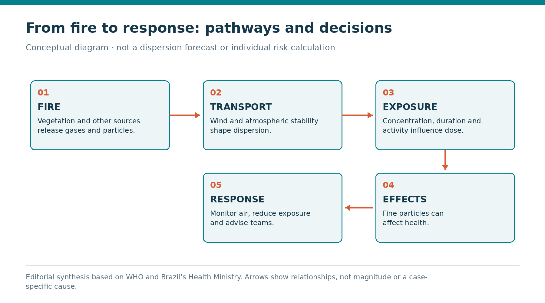
Burning vegetation releases a mixture of particles and gases. Wind transports that mixture, while atmospheric stability and vertical mixing influence dispersion. Rain, terrain and the duration of emissions also matter. Consequently, a municipality experiencing smoke exposure can be far from the ignition location, and pollution can persist after nearby fire activity changes.
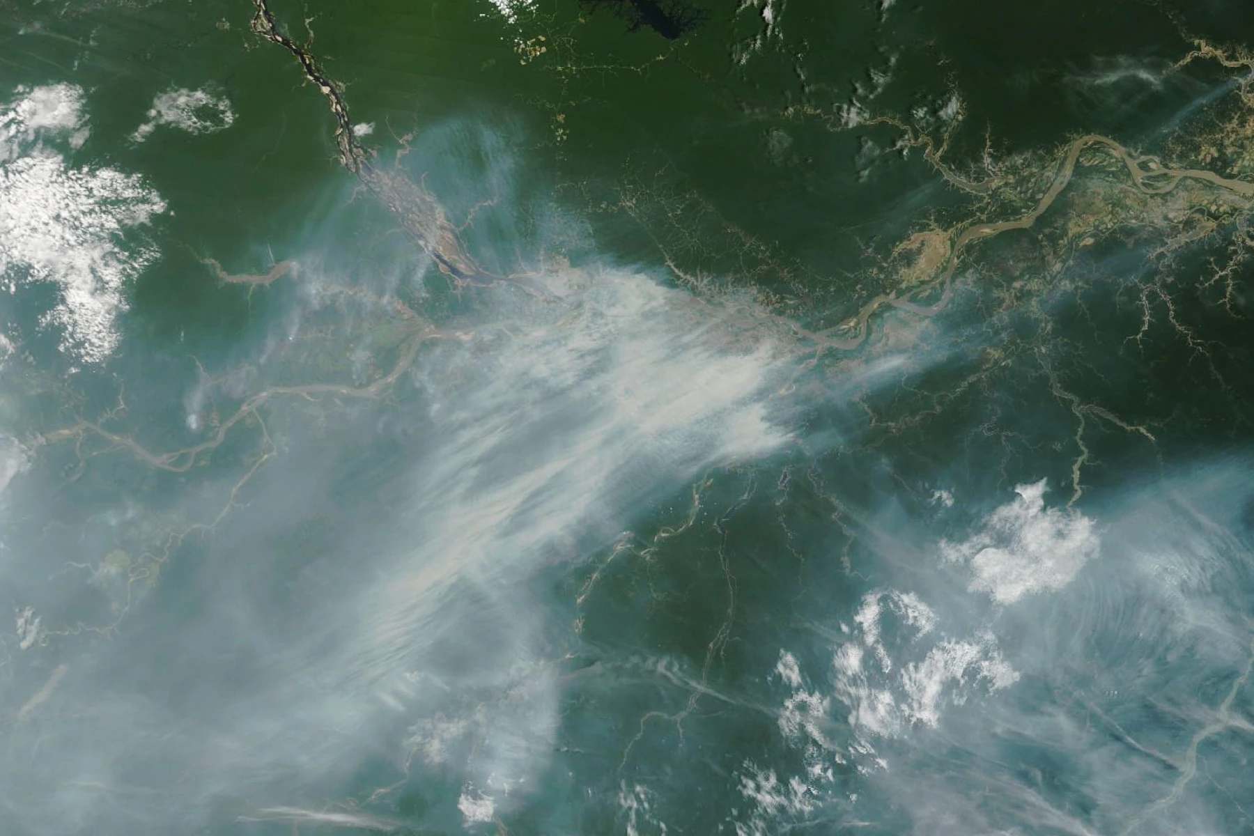
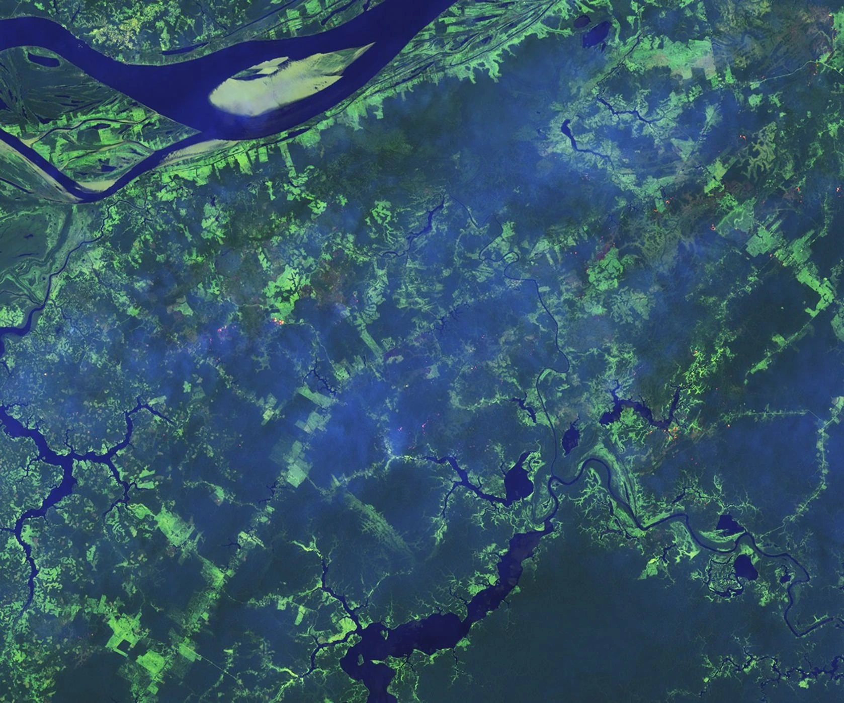
An elevated concentration in Manaus does not, by itself, identify the origin of each plume. Attribution requires combining fire observations, meteorological information and atmospheric transport analysis. A satellite image can illustrate the regional extent of smoke, but it cannot independently demonstrate a connection between one particular emission source and an individual monitoring location.
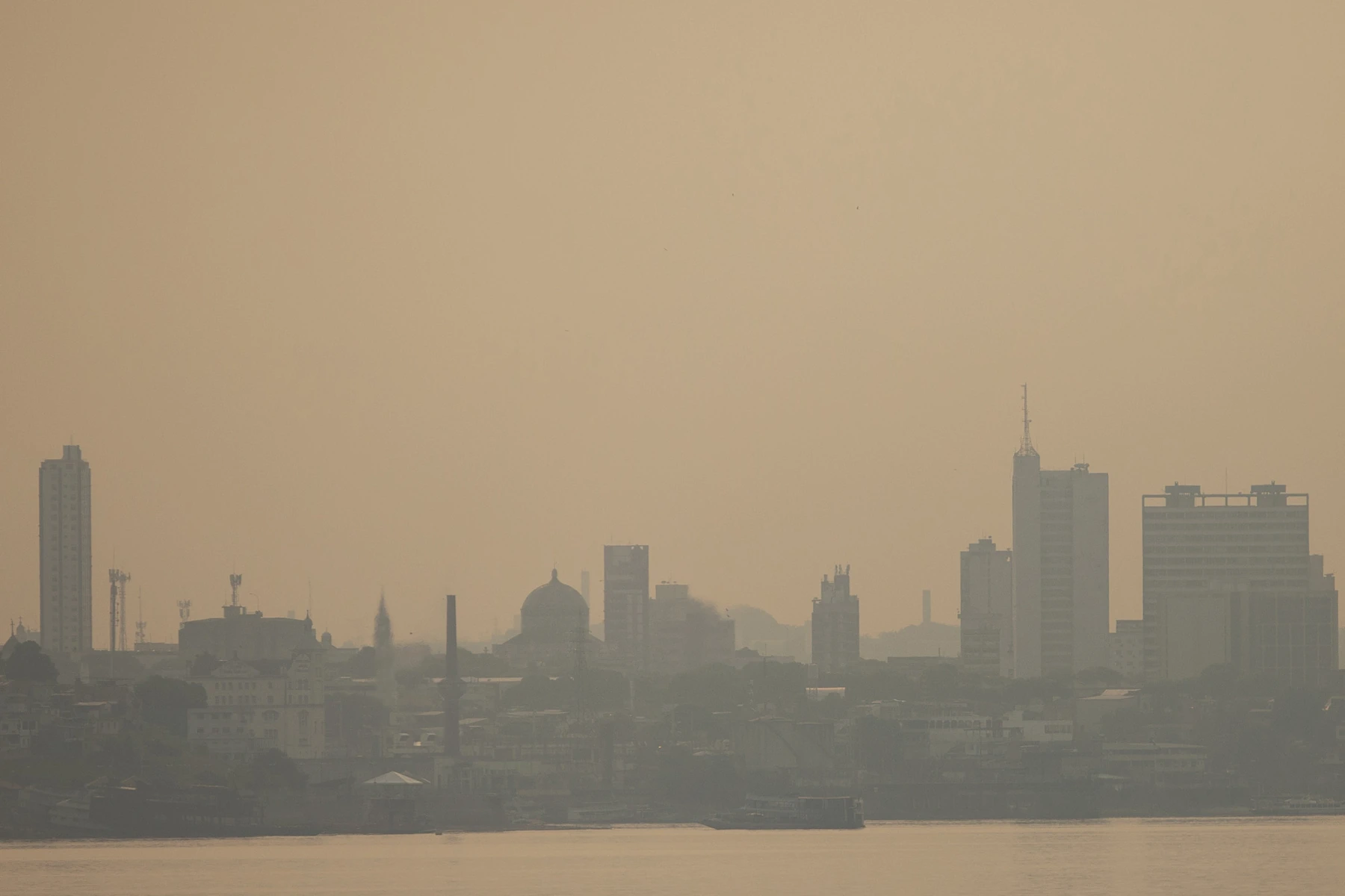
The historical photographs in this article illustrate documented situations from other years; they do not depict October 2026. This distinction is particularly important for orbital imagery. A visible plume provides spatial context, whereas the concentration breathed near the ground depends on measurements and local conditions that a photograph alone cannot establish.
Hotspots, wildfire events and burned area
A hotspot is a detected thermal anomaly consistent with fire, observed using a particular sensor and processing method. Spatial resolution, overpass time, meteorological clouds and vegetation affect detection. One wildfire can generate multiple observations, while a small fire or one beneath the canopy may escape detection during a particular satellite pass.
The wildfire is the physical event, developing across terrain with boundaries that require assessment. Burned area is a mapped estimate of the affected surface, produced using a separate methodology. Dividing or multiplying hotspot counts by a fixed pixel area does not convert thermal detections into hectares actually burned, whatever the precision of the arithmetic.
When following trends, preserve the same product, territory and time window, and document methodological revisions. Differences between datasets do not automatically indicate institutional error: sensors and reporting intervals can answer different questions. Misinterpretation arises when presentation hides those conditions and implies equivalence between detection counts, physical extent and atmospheric pollutant concentrations.
INPE — fire-monitoring frequently asked questions →
| Metric | Question | What it does not establish alone |
|---|---|---|
| Hotspot | Where was a thermal signal detected? | Exact wildfire count or hectares burned |
| Wildfire event | How did fire develop on the ground? | Concentration breathed in another city |
| Burned area | What surface was affected? | Detection count or PM2.5 concentration |
PM2.5: small particles with significant consequences
PM2.5 means fine particulate matter, characterized by an aerodynamic diameter of up to 2.5 micrometres. Concentrations here are expressed in micrograms per cubic metre of air, µg/m³. This is particle mass in a sampled volume, rather than a hotspot count, a visual measure of smoke density or the percentage of available oxygen.
Fine particles can penetrate deep into the respiratory system. Exposure to particulate air pollution is associated with respiratory and cardiovascular effects, and people with existing conditions can be particularly sensitive. This evidence does not attribute an individual illness, a specific hospital admission or a death count to the current episode without appropriate health investigation.
A less hazy sky does not demonstrate an absence of fine particles. Odour, visibility and discomfort provide observations, but they are not equivalent to measured concentration. Planning should combine reliable bulletins and local conditions, recognizing that smoke contains other constituents and that a PM2.5 reading alone does not characterize the entire mixture.
Reading the Manaus value of 99 µg/m³
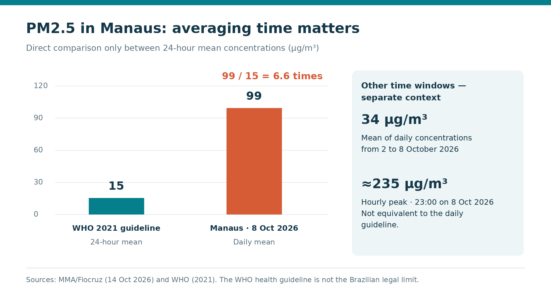
The MMA/Fiocruz statement published on October 14 reported a daily mean PM2.5 concentration of 99 µg/m³ in Manaus on October 8. The WHO 2021 guideline for 24 hours is 15 µg/m³. Comparing compatible durations gives 99 / 15 = 6.6: that day's concentration was 6.6 times the guideline value.
The same statement reported an hourly peak of approximately 235 µg/m³ at 11 p.m. on October 8 and a mean of daily means of 34 µg/m³ for October 2–8. These are three different statistics. We do not divide the hourly peak by the daily guideline or present 34 as another daily measurement for October 8.
The guideline is a health-based reference, rather than a universal Brazilian legal ceiling or a boundary of zero risk. For the 24-hour recommendation, WHO also specifies the 99th percentile of the annual distribution, equivalent to about three to four exceedance days per year. The concentration ratio of 6.6 does not calculate individual illness risk.
MMA/Fiocruz — air-quality monitoring →
WHO — pollutants and air-quality guidelines →
WHO — global air-quality guidelines questions and answers →
| Reference or observation | PM2.5 value | Window |
|---|---|---|
| WHO 2021 guideline | 15 µg/m³ | 24 hours; recommendation tied to annual 99th percentile |
| Manaus — daily mean | 99 µg/m³ | October 8, 2026 |
| Manaus — mean of daily means | 34 µg/m³ | October 2–8, 2026, seven days |
| Manaus — hourly peak | ~235 µg/m³ | October 8, 2026, 11 p.m. |
Better monitoring also means understanding coverage
On October 14, the MMA described expanded monitoring through FioAres, developed with Fiocruz. The five stations mentioned are located in Manaus, Rio Branco, Porto Velho, Belém and Santarém. This is regional infrastructure: simply listing those cities shows why they must not be described as five stations located within the state of Amazonas.
A station represents its observation location and period. Distance from sources, siting and meteorological conditions can produce differences between neighbourhoods and municipalities. Its data support surveillance and public decisions, but do not establish that everyone across the state breathed precisely the concentration recorded at a particular monitoring point in Manaus.
When consulting a platform, check timestamp, units, averaging duration, method and data availability. A missing reading does not mean zero concentration. Satellites and ground stations complement one another: the former help locate fire signals and plumes; the latter track concentrations at monitored locations, with spatial and instrumental limitations that should remain visible.
Who needs attention, and which jobs change?
Children, older adults, pregnant people and those with existing respiratory or cardiovascular conditions require particular consideration in protection guidance. Indigenous and riverine communities also need communication and access to services suited to their territorial conditions. Other groups are not immune: reducing smoke exposure remains a collective public-health objective rather than an issue restricted to vulnerable individuals.
Construction, sanitation, delivery, transport, maintenance and rural work can involve prolonged contact with smoky air. Physical exertion increases air demand and should inform planning. Assessment needs to consider the task, duration and environment, avoiding an assumption that everyone with the same job title has identical exposure regardless of location or working conditions.
Fire crews face an additional combination of hazards: fire behaviour, heat, terrain, visibility, communication and atmospheric conditions. General public guidance does not define protection for a team at the fire front. Specialist operations require assessment and procedures suited to these hazards, appropriate resources and trained personnel, including arrangements for changing conditions during the operation.
Brazilian Ministry of Health — wildfire smoke guidance →
Brazilian Ministry of Health — smoke surveillance and guidance →
Reduce exposure through several layers
Brazil's Ministry of Health emphasizes following official alerts, reducing time and exertion outdoors during smoke episodes and seeking protected environments. For employers, this requires concrete decisions: postpone nonessential outdoor tasks, reorganize travel and arrange breaks in places that actually reduce smoke entry, taking account of local conditions and the practicality of available alternatives.
Closing doors and windows during smoke intrusion can help limit entry. This measure also requires attention to indoor heat and safety; people should not remain in an overheated space simply to keep windows closed. Appropriate, well-maintained filtration can contribute to protection, without making every indoor room automatically safe or removing the need to assess conditions.
Communication should identify who monitors advisories and who can change activities. People with symptoms or worsening existing conditions should seek health-service guidance according to their needs and local alerts. This article does not prescribe medication, make a diagnosis or replace official recommendations and individual assessment; its purpose is to explain practical exposure reduction and its limits.
Respiratory protection is one barrier, with limitations
When going outside is necessary, official guidance includes properly fitting PFF2/N95 respirators to reduce particle inhalation. Fit matters because leakage reduces protection. Selection must consider the wearer and appropriate advice: distributing the same model indiscriminately is unsuitable, particularly for very young children and infants, whose needs cannot be addressed by a generic adult recommendation.
Particulate filtering respirators do not remove carbon monoxide or all gases in smoke. They do not supply oxygen or protect against heat and an advancing fire. A PFF2 does not make a wildfire atmosphere safe and cannot replace the operational controls required for firefighting or emergency response, whatever its particulate filtration performance.
At work, selection and use belong within exposure assessment, training, fit, maintenance or replacement and other applicable controls. Issuing equipment without reviewing tasks and shelters leaves other barriers weak. This article does not establish a universal respirator requirement or derive an occupational exposure limit from an urban ambient-air measurement reported for a different place and time.
Mobilized resources are not the same as resources operating
In its October 12 statement, updated October 13, the MMA reported mobilization of 11 aircraft and 290 firefighters for Amazonas. Six aircraft were already in the state at the time of the communication. This does not establish that all 11 were operating then, or that the same number remains deployed today.
Response involves coordination among institutions, identification of priorities, logistics, communication and crew safety. Aircraft and fire teams are essential resources, but an announced quantity does not independently measure territorial coverage, suppression effectiveness or community protection. Weather and operational availability also influence what can be achieved on each mission, making deployment status important alongside procurement or mobilization announcements.
Prevention continues before and after immediate response: reducing avoidable ignitions, enforcing land-use rules, detecting fires promptly and planning ecosystem recovery. Suspected intentional fires mentioned by authorities must remain described as suspicions under investigation. There is no basis here to assign criminal responsibility to every occurrence or anticipate conclusions about particular individuals and their actions.
A decision routine for managers and safety professionals
A useful routine begins with checking official bulletins and identifying smoke-sensitive tasks. The responsible person should record the source, timestamp and observation period used. A historical daily mean from October 8 should not be presented to a crew as a current reading for their construction site on October 14, however relevant the historical episode may be.
Next, assess who works outdoors, the required exertion, alternative ways to perform tasks and available shelters. Reorganizing services and stopping an activity when necessary are management decisions; criteria need to be communicated and consistent with local authorities and technical assessment. We do not create a proprietary risk index or an automatic medical trigger from these numbers.
Follow-up should include changes in wind, rain, air quality, alerts and control availability. Documenting decisions supports learning, including when a measure did not work as expected. Resuming normal activity requires reassessing conditions and communicating the decision: a reduction in hotspot counts does not establish an immediate improvement in the air that workers and communities breathe.
| Stage | Practical question | Useful record |
|---|---|---|
| Consult | What advisory and averaging window? | Source, place, timestamp and units |
| Identify | Who is exposed and for how long? | Task, exertion and duration |
| Control | Can work be reorganized or stopped? | Alternatives and decision owner |
| Protect | Does shelter reduce smoke without worsening heat? | Control conditions and availability |
| Reassess | What changed to support resuming work? | Fresh assessment and communication |
Climate favours spread; ignition asks a different question
Heat, drought and altered rainfall can dry vegetation and favour fire spread. INPE is monitoring the 2026–2027 El Niño event; its analyses provide climate context and outlooks that change with new information. They are not deterministic predictions of fire in each municipality and do not establish the ignition source of a particular event.
Climate change concerns background conditions and probabilities, while formal event attribution requires its own methods and evidence. Land use, ignition sources and response capacity also affect damage. Reducing the explanation to one cause makes it harder to identify preventive measures that remain possible, and confuses conditions supporting fire with verified responsibility for starting it.
For subsequent developments, separate comparable hotspot series, specific burned-area products, PM2.5 averages, health bulletins and operational information. Each update requires a source and date. This article neither estimates hectares burned nor forecasts hospital admissions; it explains how to interpret different signals without converting general associations into local conclusions that the available evidence does not demonstrate.
Explore documented data without mistaking it for live monitoring
The downloadable explorer contains the closed dataset used in this report, with Portuguese, English and Spanish options. It allows comparison of 277 and 644 hotspots within the same INPE interval and Manaus's daily mean against WHO's 24-hour reference. It does not receive automatic measurements or replace official information platforms used for current decisions.
The hourly peak of 235 µg/m³ and the mean of seven daily means of 34 µg/m³ retain their separate windows. A CSV file supports checking indicators, periods and sources. Displayed ratios and differences are arithmetic operations on documented values, rather than health indices, forecasts or personalized exposure assessments, and should be read with those limitations.
The photographs show explicit credits and years; conceptual figures explain mechanisms and methodology. When sharing a chart, preserve its units, caption, geographical scope and reference. Removing the date from emergency data can make a historical value appear current and lead to poor decisions, even when the calculation and visual design remain mathematically correct.
Prevention continues beyond the flames
The episode demonstrates why environmental monitoring, public health and occupational safety need to work together. The same smoke crosses administrative boundaries and reaches communities and crews with different protection capacities. Response improves when reliable observations lead to verifiable decisions about activities, shelter, communication and assistance, without waiting for every indicator to tell an identical story.
The emergency is also in the air that communities and workers breathe. To develop preparedness further, we link existing analyses of El Niño and work, emergency response in Nepal, investigation methods and spill containment. These are distinct contexts connected by the need to identify hazards, recognize evidential limits and strengthen barriers before conditions deteriorate.
Frequently asked questions
What is PM2.5, and why does wildfire smoke matter for health?
PM2.5 is fine particulate matter with aerodynamic diameter up to 2.5 µm. It can reach deep respiratory regions, and exposure is associated with respiratory and cardiovascular effects. This does not establish an individual diagnosis.
What does the figure of 1,679 fire occurrences mean?
It is the count attributed to Censipam by Reuters for the first two October weeks of 2026 in Amazonas state, up 253%. It does not automatically mean 1,679 independent wildfires or hectares burned.
Are hotspots the same as individual wildfires or burned area?
No. They are thermal detections affected by the sensor and observation conditions. One event can produce multiple detections; burned area requires separate mapping. Counts from different datasets must not be added.
Why does 644 versus 277 produce a different increase?
The MPC-AM bulletin compares the same INPE reference satellite AQUA_M-T and October 1–7 in 2026 and 2025. The increase is (644−277)/277×100 = 132.49%, or 132.5%. This differs from the Reuters/Censipam reporting window and dataset.
What do the Manaus measurements show?
MMA/Fiocruz reported a daily mean of 99 µg/m³ on October 8, 2026, an hourly peak of about 235 µg/m³ at 11 p.m. that day, and a mean of daily means of 34 µg/m³ for October 2–8. These are separate windows.
Does 99 µg/m³ mean illness risk was 6.6 times higher?
No. The calculation 99/15 = 6.6 compares a daily mean concentration with the WHO 24-hour guideline. It does not provide an illness multiplier, an individual prognosis or a universal Brazilian legal limit.
How does Brazil’s Ministry of Health recommend reducing exposure?
Follow official alerts, reduce time and exertion outdoors and seek smoke-protected interiors while considering thermal comfort. When going outside is necessary, properly fitted respiratory protection can reduce particles. Symptoms require health-service guidance according to need.
Does a PFF2 provide complete protection for a firefighter?
No. Particulate respirators do not remove CO and all gases, supply oxygen or protect against heat and advancing flames. Firefighting requires specialist assessment and controls; issuing masks alone is insufficient.
Are all five FioAres stations in Amazonas?
No. The October 14 statement lists Manaus, Rio Branco, Porto Velho, Belém and Santarém. This is a regional network, and one monitoring point does not automatically represent the entire state or every person’s exposure.
Does the explorer provide live readings or medical risk estimates?
No. The download uses a closed historical dataset with sources and periods. It supports checking arithmetic comparisons; it does not update readings automatically, create a health index or assess individual exposure.
References
- Reuters — Amazonas fires, KFGO republicationReuters / KFGO
- MMA/Fiocruz — air-quality monitoringMMA / Fiocruz
- MPC-AM — October 8 bulletin using INPE dataMPC-AM / INPE
- MMA — aircraft and fire crew mobilizationMMA
- INPE — fourth El Niño 2026–2027 bulletinINPE
- Brazilian Ministry of Health — wildfire smoke guidanceMinistério da Saúde
- WHO — pollutants and air-quality guidelinesWorld Health Organization
- Brazilian Ministry of Health — smoke surveillance and guidanceMinistério da Saúde
- NIOSH — wildfire smoke and outdoor workersCDC / NIOSH
- NIOSH — respiratory protection against smokeCDC / NIOSH
- MMA — Brazilian ambient air-quality standardsMMA
- WHO — global air-quality guidelines questions and answersWorld Health Organization
- INPE — fire-monitoring frequently asked questionsINPE
- archive-photo.webp — Bruno Kelly / Amazônia RealBruno Kelly / Amazônia Real
- CC BY 2.0Creative Commons
- plume-photo.webp — NASA Earth Observatory / Lauren Dauphin, MODIS data NASA EOSDIS LANCE and GIBS/WorldviewNASA Earth Observatory / Lauren Dauphin, MODIS data NASA EOSDIS LANCE and GIBS/Worldview
- Public domain — US NASANASA
- understory-photo.webp — NASA Earth Observatory / Lauren Dauphin, Landsat data US Geological SurveyNASA Earth Observatory / Lauren Dauphin, Landsat data US Geological Survey